 |
|


| You are here: Cwm > Themes > Place > : Geography of South Wales | |
 | |
|
Geography of South Wales |
|
|
|
|
|
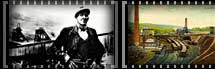
The South Wales coalfield is the largest continuous coalfield in Great Britain. It has an area of approximately 1000 square miles covering much of the old counties of Glamorgan, Monmouth and Carmarthenshire with a small incursion into South Pembrokeshire. At its broadest north-south extent, the coalfield is eighteen miles in width and the area is criss-crossed with numerous deep valleys running North- South and East-West where coal has been primarily mined and communities established. These narrow valleys are separated by upland moors and hills that, both in the past and present, make direct communication between them very difficult.
FURTHER READING: Bowen, E.G. Wales, A study in Geography and History. (Cardiff, 1952) Cynon Valley History Society. Cynon Coal. History of a Mining Valley. (Gomer Press, 2001.) Jones, Philip N. Colliery Settlement in the South Wales Coalfield 1850 to 1926. (University of Hull publications, 1969). Morris, J.H. and Williams, L.J. The South Wales Coal Industry. 1841-1875. (Cardiff, 1958) Rider, S.W. South Wales: a physical and economic geography. (London, 1926) All items listed in the further reading are available for consultation in either the South Wales Miners’ Library or the Library and Information Centre, University of Wales Swansea. Click here to link to the library catalogue.
|
|
|
|
|
|

Swansea University Special Collections
| ©University of Wales Swansea 2002 |